Museum Trail to San Jacinto and Back, August 8-9, 2021

AllTrail’s entry for the Skyline Trail: Cactus to Clouds segment describes a 21.2-mile point-to-point journey from Museum Trail in Palm Springs to San Jacinto Summit, and christens it with the challenge or warning or both that it has “the greatest elevation gain of any trail in the United States.”
Two forest rangers I spoke to on August 8th, 2021, during my second attempt to go up and back down the trail, called it the steepest trail in the country.
Along the way on the hardest hike of my life so far, I called this particular path all kinds of things.

In the end my Garmin said that, for me, this adventure was 32.45 miles and 10,957 feet of elevation gain spread over 28 hours and 12 minutes.
I saw two sunrises, one of the most restless nights I’ve experienced, magnificent views of desert, forest, mountains, and San Jacinto summit from a direction I’d never seen before.
I was convinced that I was outclassed many times, and at turns humbled and exhilarated by the relentless battery of challenges that came my way.
I left a bit of blood on this trail, and the empowerment this experience offered will never leave me.

I set a goal to take on the highest points in southern California in May 2021 as part of my training for Pine to Palm 100 on September 11, 2021 (my second attempt at the distance), and in preparation for the first Chaski running retreat in Flagstaff in early June.
Since then the pursuit of the wildest Sundays I can find has become a part of my life that I’d be sad to be without, and the benefits have been abundant.
Through this practice I get to see some of the most beautiful spots in the state, and sharing these adventures through my words, videos, and photos on my website and social media accounts has been a blast. My fitness is also demonstrably better than it’s ever been before.
During that first month I wanted to summit San Jacinto from a different direction than I took the first time I made the journey to the peak in July 2018.
Enter Museum Trail in Palm Springs, the first part of the Skyline segment.
The profile is something to see for people who like this sort of pain. It’s a wall in places, maddening in others, and endless when seen firsthand.
I don’t like easy anything, so up it went on my hit list.

In May I stayed the night about 20 minutes from the trailhead, beat the sun, and got after it.
After a very long day of climbing about a 1,000 feet or so per mile, and some of the most frustrating losses of direction I’ve ever had, I got to the ranger station at mile 10 or so and found out San Jacinto itself was another 6 miles off.
I was prepared for a 20-mile day, and going over 30 is a different game.
Sometimes I make smart choices. With the supplies, time, and energy I had on hand, I gave San Jacinto a long look, promised I’d be back, and turned around.
At 3:30 a.m. on Sunday, August 8th, I came back.

With a high of 111 degree Fahrenheit on the forecast, a lot of distance, and even more vert in my sights, I saw a few opportunities to do things differently this time around.
First, I talked to my coach Kris and friends Ty, Zandy, and Mike about how to approach the heat I was expecting. Per their advice I bought REI-branded arm sleeves, which provided protection from the sun and plenty of ventilation throughout the day.
I also one-upped my recent practice of filling bladders and bottles with ice and filling in the space that remains with water. The refreshment that comes with this helps keep me cool wherever these containers touch my body, and does wonders for the body and soul.
I brought a cooler with me to Palm Springs, and when I was close to the hotel I’d gotten for the night before game day (thinking I’d need only one night, more on that later) I bought a 20-pound bag of ice for the cooler. I then opened it on the morning of my adventure and used the ice to fill up pretty much every water bottle I own before putting them in my hydro pack.
I also used the AllTrails live navigation for the first time. The feature worked great and was essential at night. But holding a phone with hiking poles (Black Diamond Distance Zs continue to impress and meet every need) is almost impossible.
I haven’t had a need for a watch that displays a map on its face up until recently, and I think that will be a necessary next step for my running and hiking game as I continue to take on these types of projects.

I brought out brand new HOKA Speedgoat 4s for this occasion, in the special Farther Together color way the brand released a short time ago. As you can see in my meme, they made quite an impression on me from the first time I saw them. Though not every shoe works well out of the box, it’s a demand I put on all my shoes, since I expect a lot out of them immediately, and time to “break in” a product is time I don’t have. This time was no exception with my ‘goats, and their place in my heart is as high and consistent as ever.
I wore Run Lite Mesh socks by Drymax, which come with the right kind of cushioning and ventilation I was looking for on this trip. The colors also matched up perfectly with the shoes, and I liked the idea of bringing a very clean look into what would be an extremely rough-and-tumble escapade.
As I mentioned in my Coldwater Rumble 100 write up (my first 100-miler attempt in January, 2021 in Goodyear, Arizona, where I made it to over 76 miles before being unable to make the next cutoff) the NATHAN Journey hydro pack was sadly discontinued, but my friends at the brand hooked me up with it a while back. With 25 liters of storage space it’s the only choice in my quiver for long, self-sustained trips like this.
I took plenty of food (oranges, apples, protein bars, and peanut butter and jelly sandwiches), loads of caffeine-heavy GU gels, and filled up a 2-liter bladder along with front-pocket bottles, and two more water bottles at about a liter or so each, totaling maybe a gallon and a half.
A can of caramel-flavored cold brew came with me as well, which I planned to, and did, slam gloriously at the summit.
I also brought a headlamp by HOKA, a solar-powered rechargeable battery for my watch and phone, and an extra clip-on light. I didn’t bring my GoPro this time around since I didn’t want it to overheat. Like many concerns that seem like top priorities in planning, this turned out to be a non-issue, but I’ll get to that in a bit.
Very importantly, I told a fair amount of friends and family about what I was doing and where I was going. Letting multiple people know my whereabouts did a lot for my peace of mind, especially when things got rough. And when I had a signal, it meant the world to exchange texts and know I was being cheered on by loved ones from afar.
The night before go-time I slept all right, but not deeply or long enough. This is usually the case before something I’m nervous about, and I’m glad it was enough for me to have the presence of mind to check all the right items at 2:30 a.m., then check them again, and get moving.
Based on the difficulty and mileage, I’d decided to take the journey as a hike, and am glad I did. It took everything I had to do so, and I have no idea how it would’ve turned out otherwise.
I parked by the museum, sent a couple texts, snapped some photos, and started my hike at 3:30 a.m..
The Museum Trail gets its name from its trailhead being located right behind the Palm Springs Art Museum. It’s a fine title, anything that helps make a location more clear has a big fan here. But the trail could just as easily wear a name like Vertical Gauntlet or Godzilla or Opening Crawl to a Nightmare.
The angle of the climb that comes with Museum Trail was quick to take the run out of me in May. The terrain is also sharp, technical, and littered with loose rock and odd angles. Taken together, easing into the day is just not part of the equation.
Starting up the first of many, many difficult climbs, my mind went to advice from one of the best runners I know. After sharing all the details of this trail with him, he said to take things slower than I might be comfortable with. Naturally, I was happy to oblige.
But, of course, there are better athletes than me out there.
After about a quarter of a mile in, the tell-tale headlamp of a runner started sneaking up behind me. I love seeing this anywhere, and admired a pace that was definitely beyond my current abilities and plan for the day.
When he got close we said what’s up, gathered that we were both headed for the top, and he said it was all about outracing the sun while doling out energy appropriately. This struck me as pretty obvious to tell someone hitting a very difficult trail 3 hours before sunrise.
I said hell yeah or something like that, and told him my approach was going to be the most conservative I get in life.
He laughed, we wished each other well, and returned to our respective battles. I didn’t see him again, and think (and hope) he took the tram back down. It’s a fine option to take. But it wasn’t mine.

With the sunrise the temperature took off at a sprint, and I drank as much water as I could. I alternated gels and food items about every hour, and stayed slow.
But even with moderation guiding every step, I went through half of my water a third of the way through the journey.
Then came the hard part.
The space roughly between miles 9 through 10 are, without a doubt, the most difficult I’ve dealt with on a trail. A clear path forward gets mangled in rocks and bushes, or picks up on a place that doesn’t look like any place at all. The terrain is also extremely unkept and rocky, like what most trails will look like if we don’t have the heroes that are park staff and volunteers keeping them maintained and tidy.
My first meeting with this section back in May had me scrambling in a fairly precarious position. For reference it was within a hundred feet or so of the tram, which scales angles that have no subtly about them.
With views that come with a certainty that this is no place to be less than confident, it was a concerning place to be in at the time. I promised myself that when I came back, I’d stick as closely as I could to the map, and keep risking my life to a minimum.
I managed to avoid most of that this time, but was nonetheless frustrated when the same thing, of course, happened again. Soon enough the map got abstract, and I was climbing inclines that slowed me down even more than trying to find a coherent way forward.
I followed the general direction as best I could until, finally, I made it to the central hub of trails that meet at a ranger station at the peak, before one begins the 6-mile trek to San Jacinto.
The drinking fountain at the station was out of order, so I asked one of the rangers if there was any water in the area. He said it was fine for me to use a hose they had at the facility, and I got to talking with him and another ranger as I topped off my bladder and the bottles I had in my bag.
I had to ask about the troublesome home stretch to this point, and they nodded knowingly.
“Oh yeah,” they said, then shared that the reason the trail gets so unclear and infuriating is a total lack of maintenance or care.
This felt on the nose for the conditions I’d pushed through, but was also puzzling for a publicly-shared trail.
The rangers said AllTrails was a bit of a sore spot, since it’s quick to give visibility to any and all routes, but does not, in their view, give adequate warning about the dangers that come with trails like this one.
The description for Cactus to Clouds on AllTrails does state that deaths and injuries occur along this route. Regardless, the rangers shared that many of both happen every year.
I asked if it comes down to money, if the right budget could make this trail safe and ready for the numbers it seems to attract.
They disagreed. One of the rangers shook his head, looking off while he did, and I could relate completely.
The section is mayhem, and short of shaving the mountain side into an even-keeled fire road, there doesn’t seem to be any way of changing what it is.
I thanked the men, some of the best public servants we have, and they complimented what I was up to and wished me well.

The sign for six miles to San Jacinto stood where I’d left it last time. Off I went, heartened by a mere 6 miles to the summit, followed by a net downhill trek back home.
I run a fair amount, and a looped 12-mile segment is a familiar formula for me to compartmentalize and digest.
Six miles out, six miles back. Simple, if not in an easy place to do it.
And it was getting late.
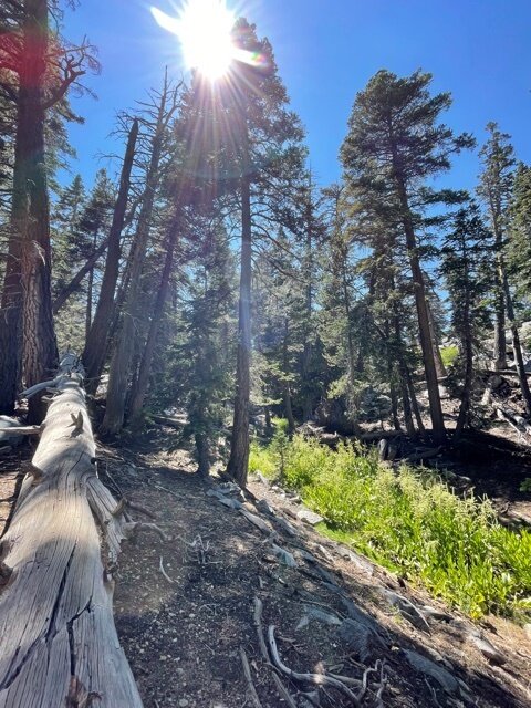
Of course it was gorgeous. One of the best parts of a healthy forest is how our limited, earth-bound perspective can let us imagine it goes on forever.
Rich foliage atop exposed earth and broken stone led me into the afternoon, then opened up with views as wide and long and life-fulfilling as any you can ask for anywhere. Conditions were cool, and the people I came across on the trail were friendly and happy to be there as well.
The trail kept climbing, and in the last quarter mile or so I made a new friend in Peter, a hiker who had come up to enjoy the summit from a nearby camping spot. We shared stories and laughs, and it was great to share the home stretch with someone who appreciates the grandeur and hardship of taking serious trails on for fun.

I got to the peak, chugged my coffee, and gave as much of myself as I could to these moments of wonder and appreciation that come with being at over 10,000 feet after a difficult 14 hours.

It was just after 6:00 p.m.. I did not have much day light left.

I’d known I would have to come back down in the dark, and figured I could count on it being faster with the downslope.
The math would seem to agree, but overlooked the difficulty that comes with next-to-nothing visibility beyond the map on my phone and a dim outline of the trail.
I turned back, and the headlamp came on around 8:00 p.m. or so. I texted friends and family right before the down slope from the ranger station. This was the segment I dreaded most, and I tempered any indication of how concerned I was.
I circled around a bit to make sure my messages got to their people, which they did. I breathed hard, and got into it.

Adding darkness to a sheer trail brimming over with loose earth and rocks is an arduous task. The scope of the effort as a whole, and how this was just the beginning, was never far from my mind, either, since the lights of Palm Springs shone clearly through the trees. For most of the way back the glow acted as a consistent reminder of how far I was from my car.
But, of course, not having a choice does wonders for motivation.
I took my worst fall at this point, losing ground on an incline, then turning in the air to land on my lower back and left arm.
I took a second to account for what hurt. I took my time getting back up to make sure I wasn’t making anything worse by doing so. My arm bled a bit, breaking in my arm sleeves somewhat dramatically, and my back felt banged up, but solid.
Everything seemed functional, and I washed the dirt out and drowned the cut in hand sanitizer.
I breathed deep, congratulated myself on falling the right way, and reminded myself that staying loose and rolling with gravity would have to be a part of any future falls.
There were more, for sure, the numerousness going from annoying to funny to downright infuriating after a while.
But, that’s a part of this, too. And I went on.
As tedious as it was to focus on the map, terrain, supplies, and the state of my body all at once, I suspect that having these demands also gave me one of my biggest wins of the journey: working through a lack of sleep.
This was a major reason why Coldwater didn’t work out for me, and I think that with training I’ve gotten much better at performing through fatigue, which is heartening as I post this 18 days out from Pine to Palm.
None of this, however, took away from what it took to finish this project.
True to form, I lost the trail a couple times, and went in the wrong direction a few more. There’s a special frustration that comes with finding out you’ve wasted precious time and energy on absolutely nothing.
I do my best to stay calm in these moments, since in many survival stories I’ve come across, losing out to panic and despair is a dangerous step towards serious consequences.
I’d look down and find the blue dot that was me some distance away from the red line that I needed. Looking up, the bulk of the rolling hills shrank the city lights ahead, promising that I was still hours and hours away from finishing this.
The choice between weakness and resilience becomes very clear at these times.
And the term “going through the motions” turns into something like a North Star.
Inspiration can’t be counted on. Joy can, in my experience with running and hiking. But exhaustion will drain on these feelings, in due course. The motions, however, are not dependent on one’s emotional state.
You move the body, in anger, in despair, in bewildered, empty surrender to something that is harder than you should have stepped up to.
And there is absolutely nothing the task can do against each step you make, as big or small as it may be.
Intimidation shrinks. Sharp edges get blunted, and I went over all the things I had going for me: water, food, the map, a healthy inventory of supplies, and resolve.

After a full night of hiking with only momentary breaks, the second sunrise of the journey arrived. The morning was quick to set the temperature in the 80s and 90s as I approached Museum Trail again.
I got texts from people sending me good recovery vibes, which were soon followed by surprise when I responded that I was still out here. But I was almost there, and had everything I needed to finish.
The home stretch never got easier, and definitely got hotter. After the slow descent back down Museum Trail, it felt odd to find level ground on the asphalt again, then felt glorious as my car came into view.
I gave Sporty (my ’17 Kia Sportage) a triumphant spank on the rear, and immediately started eating and drinking water and texting people to let them know I had completed the mission. I was parked safely as I did so, and the hours upon hours of sustained effort were quick to catch up with me.

I started nodding off between texts. Like my experience at Coldwater, I didn’t necessarily feel sleepy, but would lose focus and watch as dreams started to play out in front of me.
The safe choice in this situation is to always take more rest time than less.
I booked another night at the Motel 6 (East Palm Canyon) to meet my body’s immediate need to get horizontal. I let the front desk know what I’d just done, and told them it would mean everything to me if they had a bed ready at the moment.
It was absolutely heavenly to hear the young man on the other end of the line tell me, “Sir, we’re ready when you are, we’ve got you.”
I picked up breakfast and coffee, wolfed down the steak and eggs and fruit like I was being timed, and had to make two trips to get all my items into the room before a work call.
I woke up about three hours later, having missed the call and leaving my coffee in my car. Either one of those things happening means I am not myself at all.
My team fully understood and appreciated the situation when I explained it, and were glad I was all right.
After jotting down more thoughts as they came to me and eating more, I thought, well, I’m in Palm Springs, might as well check it out. Being reduced to a slow hobble wasn’t going to effect the fun I could find in the area, so I reached out to a good friend, got a solid recommendation for a dinner spot with good drinks, and got ready to go.
Again, my circadian rhythm took the wheel.
“You’re hilarious, bud. Here, check out these dreams for 10 hours.”
I woke up the next morning, felt better than I thought I would, and left for home.
I told a good friend that, as grateful as I am for the experience, I never want to see this mountain again. I said the same thing after my first marathon, and have thought about it during plenty of races and training runs in the past.
This was certainly the hardest hike of my life, and one of the most trying times I’ve been through so far. Taking on the challenges that call for those sorts of adjectives have given me growth and empowerment every time.
Digging in and expending every effort on tasks I’m not totally sure I can accomplish demand more of myself than I think I have, and reveal more parts of myself than I thought I knew I had before.
Pine to Palm 100 certainly fits these definitions for me.
I have no idea how I’ll do. But I know what I can do now. And doing it all with a glad heart, with a community and lifestyle and privileges and blessings that just keep making me better at what makes me happy and happy to see myself get better at it, is all I can ask for.
